Southeast U.S. on Alert: 'Imelda' Looms as Humberto Spins Up into Major Hurricane Threat
Two major Atlantic storms, including Humberto, are on track for the East Coast. See the potential impact & the science behind the Fujiwhara Effect.
 Selina Smith
As the Atlantic hurricane season shifts dramatically into a higher gear following the passage of Hurricane Gabrielle, a dual threat is emerging from the central Atlantic—one a powerful, intensifying storm, and the other a fledgling system that poses a far more immediate and complex danger to the United States and the Bahamas. Tropical Storm Humberto is projected to achieve major hurricane status, yet the system meteorologists are truly urging the Southeast U.S. to watch is the next in line: the burgeoning 'Future Imelda.'
While the precise path and intensity of 'Imelda' remain shrouded in the characteristic uncertainty of early-stage tropical development, the potential for a U.S. landfall, or at least a prolonged period of dangerous coastal impacts, is increasing for early next week. The complexities of this forecast are further amplified by a potential, rare meteorological interaction between the two systems, creating a fascinating, yet highly volatile, scenario that demands constant monitoring. Coastal residents from Florida up through New England are being advised to finalize their preparedness plans and pay close attention to updates from weather.com as the models gradually coalesce on a clearer picture in the days ahead.
Humberto: Powerful, But Keeping Its Distance
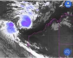
Tropical Storm Humberto has continued its steady organization and trajectory, currently situated several hundred miles east-northeast of the Leeward Islands. Traveling toward the northwest, the system presents no imminent danger to the immediate Caribbean island chain. However, its continued movement over deep, warm ocean water and through an environment generally supportive of intensification means it is forecast to become the season's third hurricane this weekend.
Forecasters anticipate Humberto will reach its peak intensity as a major hurricane (Category 3 or higher on the Saffir-Simpson Scale) as it curves northward through the central Atlantic. This powerful storm will generate significant swells and high seas, making it a substantial threat to Bermuda early next week. While the current forecast strongly suggests Humberto will remain an ocean storm, carving a path well east of the U.S. coastline, the sheer size and wind field of a major hurricane mean its indirect impacts—namely, churning up the Eastern Seaboard—will be unavoidable. The forecast cone, represented by the red-shaded area showing the potential path of the center, highlights this offshore curve, assuring U.S. mainland residents that, for now, the threat remains low. Yet, this relative safety contrasts sharply with the looming danger posed by the system trailing behind it.
The Development of 'Future Imelda' (Invest 94L)
The primary concern for the Southeast U.S. stems from a tropical wave currently designated as Invest 94L. This disturbance is moving sluggishly through Hispaniola, already wringing out widespread, locally heavy rain and gusty winds across the Dominican Republic, Haiti, and Puerto Rico. This activity is forecast to spread westward, impacting eastern Cuba and the Bahamas over the next 48 hours.
The term ‘Invest’—short for Investigative Area—is a technical designation used by the National Hurricane Center (NHC) to identify areas that forecasters are actively watching for tropical cyclone formation. It is a critical step in the forecast process, allowing meteorologists to run specialized computer models (Spaghetti Models) and gather enhanced satellite data.
It is precisely when Invest 94L emerges from the landmasses and enters the open waters near the Bahamas that forecasters expect it to tap into the available energy, leading to its organization and the eventual naming of Tropical Storm Imelda by this weekend. The latest NHC Development Chance outlook shows a high probability polygon covering the area near and north of the Bahamas, confirming the increasing odds of tropical genesis.
Two Scenarios Emerge: The Perilous Choice
The forecast track for 'Future Imelda' beyond the Bahamas is fraught with considerable uncertainty, a common feature of tropical systems in the late stages of September when steering currents can be weak or complex. Most computer forecast models currently draw Imelda northward through or near the Bahamas through Sunday, setting the stage for a critical divergence early next week.
Two primary, and widely different, scenarios are currently being discussed among meteorologists:
- The Carolina Threat: In this ominous scenario, a weakness in the steering flow allows Imelda to continue its northward movement. This would put the system on a direct collision course with the U.S. East Coast, with the Carolinas being the most likely point of impact. Given the deep, warm Ocean Heat Content available in this region—a key ingredient also responsible for fueling the rapid intensification of Hurricane Gabrielle—Imelda has the potential to grow into a hurricane before making landfall. A strike as a tropical storm or hurricane would bring widespread damaging winds, significant storm surge, and torrential rainfall to a densely populated coastline.
- The Stall and Turn: The second scenario offers a measure of relief for coastal communities. In this model, Imelda stalls offshore for a day or two early next week, caught in a complex atmospheric pattern. During this stall, the system could either be steered harmlessly east, away from the coast and possibly toward Bermuda, or it could be absorbed by the much larger circulation of Hurricane Humberto. This scenario, while preferable, still entails days of close calls and high anxiety for residents as the storm potentially hovers just beyond the continental shelf.
Widespread Impacts Beyond Landfall
It is crucial to understand that even if Imelda avoids a direct U.S. landfall, its proximity will guarantee significant and dangerous coastal impacts. The combined effect of both Humberto churning up the far offshore waters and Imelda drawing close to the continental shelf means that days of onshore winds are likely to generate dangerous high surf, life-threatening rip currents, and at least moderate coastal flooding up and down the entire Eastern Seaboard, stretching from the beaches of Florida all the way to New England.
Furthermore, Imelda does not need to cross the coast to cause wind damage. Similar to what occurred with Hurricane Erin in August, Imelda could draw close enough to produce strong, potentially destructive wind gusts along parts of the Southeast coast, particularly North and South Carolina.
The rainfall forecast is also concerning. Even without the 'Future Imelda' threat, the Southeast—specifically the Carolinas and Virginia—is expected to receive areas of locally heavy rain Friday through the weekend from unrelated systems. This pre-existing rain, despite ongoing drought conditions in some areas, means the ground is already nearing saturation. If Imelda subsequently makes landfall or its outer bands spread heavier rain into these areas, the threat of flash flooding will be significantly enhanced, transforming a simple tropical rain event into a dangerous flood situation. All interests in the Bahamas, the U.S. East Coast from Florida to North Carolina, and Bermuda must closely monitor the evolving progress of this unpredictable forecast.
The Weird Possibility: A Tropical Dance
Adding another layer of meteorological intrigue to this already complex forecast is the distinct possibility that Humberto and Imelda could interact closely enough to perform a kind of circular dance known to meteorologists as the Fujiwhara Effect.
This phenomenon occurs when two tropical cyclones of similar size and intensity approach each other. Rather than simply moving past one another, they begin to orbit a common center point. Depending on the systems' relative size and strength, the outcome can vary dramatically. Sometimes, the larger and more dominant system will grab hold of the smaller one and absorb it entirely, essentially winning the 'dance.' Other times, both systems creep closer and spin around each other before finally breaking away to continue on their separate paths. This effect is rare but has occurred in recent years, most notably in the Pacific Basin with tropical storms Emilia and Fabio last year.
In the case of Humberto and Imelda, the Fujiwhara interaction could be the wild card that determines the fate of the smaller system. If this interaction happens, and if Humberto is strong and large enough, its influence could pull Imelda away from a U.S. landfall, or even completely absorb it. While this is a lower-probability scenario, it is one that forecasters are actively tracking, spelling out the potential impact for residents should this fascinating meteorological 'dance' become more imminent.
Sources:
- Hurricane season to get busier with two storms that may threaten East Coast
- The natural tendency towards symmetry of motion and its application as a principle in meteorology


![AutoZone Business Hours [2025]: Complete Guide to Store Times, Holidays & Tips](https://statesidemagazine.com/uploads/images/2025/06/image_380x226_6852d31a038d7.jpg)